Pages

Wednesday, June 29, 2005

Dingle Brook Trails


Final Burr Farm, Newtown Forest Association Lands, Open Space Ride map. The little circles are waypoints that mark either interesting features trail junctures or deadends. If you want to download the GPX data, I would recommend going to Crankfire.com where you get can get the individual trails or I think the whole shooting match. Once I get up and running with Bikerag's mapping software, I will have update on that site as well. Posted by Hello

Sunday, June 26, 2005

Table Top Paul


Interesting geologic feature on the blue trail, surprisingly not marked on the map. This slab of rock is independent from the one its sitting on and it doesn't wobbel at all. This feature is right in the middle of blue trail as you head down to the old mica mine.Posted by Hello

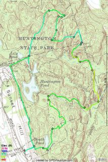
Huntington SP Ride - Blue Trail


Rode six miles today with Paul, a friend of mine from work. It was really, really hot but still a great place to ride for newbies. This place is primarily laden with alot of dual track and if want single track, you have to look for it. When you find it, take it! All sorts of little jumps and obstactles on these little side trips. I will definitely return, in fact, some of the dual track was so flat, I will be bringing my daughter here for a trailer bike ride.Posted by Hello

Sunday, June 19, 2005

Father's Day Ride in Sunny Valley Preserve


Finally got over to Bridgewater to ride this place. I have been looking at it online for quite sometime and got the map from the Nature Conservancy but finding the opportunity to go off on my own is increasingly difficult when you have two kids constantly viaing for your attention.

While I studied the terrain it still surprises me every time I ride - these trails basically zig-zag up and down the ridge along Lake Lillinonah. Down hill is fun but the uphill is hike-a-bike city. I saw one other MTB'er as he was finishing his ride other than that, besides a few lost hikers (who overshot their destination) there was no one else to see.

Going from Iron Ore Hill, down, to Rock Hill Road there is a nice stream that can be forded or ridden over on a nice bridge.

The trail continues up along stream but you can also ride the road to the next trail. Apparently its been moved due to logging. Where the trail was, it looks like a grass driveway now. I suppose you could ride that but except for the climbing aspect, it doesn't seem very challenging. Coming back down might be fun but I would rather stick to trails.

Once you get to the top of the next ride, its all downhill from there to Hemlock Hill. Turned around and started to climb. It was gradual enough that I was able to climb most of it.

After passing Rock Hill on the way back, I took the red trail for less gradual climb back to Iron Ore Hill. I was able to ride most of the climbs but there were still a few hike-a-bike opportunities.

All in all, a good work out trail but lacking in flat out riding opportunities.

This doesn't mean I won't go back because there are still additional trails that have to be ridden.

Sunday, June 12, 2005

Larkin State Bridle Trail


Trailer Biking - Katie and I on a 10+ mile ride from Southbury, CT to Naugatuck, CT on the Larkin State Bridal Trail. Its an old railroad bed that was converted to Bridal Path and mountain biking is permitted as well. You can ride all the way to the Waterbury City Limits. We got as far as Naugatuck.

The Snack seems to be getting a lot of traffic lately from people looking for info on this trail so as a service to you here are some links you might find useful:

History of the trail
Hand Drawn Map of the trail (from History Page)
Latest Ride with a great map
Crankfire Map

Two tick bites and a dose of Doxycycline


Found a really great trail (green) that follows along the banks of the Dinglebrook, crosses over the main trail that connects Burr Farm to the NFA lands and then winds its way back to the trail (yellow) I found the first time but decided it wasn't going to lead to anything good.

If you want to ride these trails, I would recommend parking at either Pond Brook Boat Ramp located off Hanover Rd in Newtown or the Burr Farm openspace park. If you park at Pond Ramp, take a right when leaving the parking area (onto Hanover Rd) and take the first left, prior to a hill. This is Pond Brook Road. After crossing the brook whence the road's name comes from, the road turns to dirt. Immediately after the next bridge, approximately half a mile down the road you will cross the brook again. On the West side of the bridge, turn right.

Follow the trail as it follows the course of the stream and it will gradually move inland. At the point where the trail turns a sharp right and goes through a stone wall you see two dead trees about 10 feet apart. Proceed straight through, keeping the stone wall on your right and follow the stone wall until you see a big oak tree on the other side of a stream bed (dry now, but wetter in fall and early spring). Other side of the oak tree is the green trail. Best route on this trail is to ride it counter clockwise, unless you like to hike your bike.

If you want to ride the Burr Farm Open Space loop, I would recommend riding it clockwise. The climb from the bench at Dinglebrook on the ride is really gradual.

When I got back to my house after riding I found two ticks attached me. I thought they were deer ticks but I could be mistaken. After removing them, I took them to the town health department where they will get tested for Lyme Disease. The health department gave me a cool frisbee for doing this. Later that day, I went to the doctors office for a dose of Doxycyclene - I am not taking any chances.

Tuesday, June 07, 2005

Burr Farm NFA Ride Work In Progress


I found the trail that connects the old road along the river to the NFA land and town open space! Of course, I didn't see it on the way in, rather the way out. If you zoom in at Waypoint 31, you will see where I added in line that goes to WP 22 which is at the edge of the open field (white on the topo). Not sure where this trail goes but on the map there is house in that direction the field is no longer NFA land.

WP 31 is the intersection that is a connector trail to the main trail. It was covered with Barberry and that is why I missed it on the way in but on the way out, I marked WP 29 where the trail branches and thus connects with the trail out. At WP 12, there is a trail heading off into the woods that may or may not hook up at WP 27. Next time I ride this area I will go that way and see what's up.

I did try to find a connection at from WP 11 that meets up with trail between WP 15 & 16 but got as far as WP 24. There is an animal path but not something that I would want to ride on a regular basis. I think next time I need to go up to WP 4 and see where that goes.

Overall, the Burr Farm is noobie ride, with the exception of the roller in the middle of the ROW (Lake George Rd), these are green trails. However, as far as quick workout goes, they are perfect.Posted by Hello

Monday, June 06, 2005

Trailer Bike.


I went out and purchased a trailer bike for Katie this weekend. At first she was scared when we started out but shortly after not only did she get the hang of it, she loved it! I went to EMS and picked up a few biking things, like a handlebar bag for her snacks which she must always have. We used to run on a railtrail in Ridgefield where she would sit in a jogging stroller and I would feed her cookies or crackers and she would sip water for the five mile round trip run.

We parked at Pepper Street and rode down to the bottom of Great Hollow Lake. We turned around about 0.2 miles from Purdy Hill and then rode back. We went past the car at Pepper Street and rode to the end of the trail which abruptly stops at what I think is the townline. The trail continues but its more single track riding and very narrow with over growth. So we headed back to the car. Our next ride will be the Larkin Trail in Southbury.

Thursday, June 02, 2005

Brought home a Christmas Tree!


So, here are the results from this morning's ride. The green track is from today's ride, the red is my initial Burr Farm OS ride, the dashed blue lines trails that may or may not exist (I will explain, later).

As you can see I didn't quite find the loop that I was looking for by the fact that I had to turn around (appoint 16). At WP 15 there appeared to be a trail that may head down to Pond Brook but I wasn't sure. There might also be a trail that hooks back to the main trail, that is why I put the blue dashed line because I don't really remember. What I do remember about this location was trying to up a small stream bank, hitting a rock, and going Endo (over the handle bars). That was fun.

The trail that leaves the red trail at WP 3 is a nice ride, nothing too steep or technical, in fact you can really get going through there. At WP, 4 there is a trail that intersects that was marked with orange engineer tape. At WP 11, there is a trail that branches to the north and heads down hill. Might have to see where that goes on the next ride. At WP 12, there is a nice stand of pines. WP 13 there was trail branching off from here that headed down the hill and looked to go towards the fields (shown on the topo from the previous post). I think this might lead to the trail along Pond Brook.

After turning back from WP 16 I probably should of headed down the hill from WP 15. It really didn't look like a trail but it would have mostlikely brought me to the one that I found after back tracking almost half way back to WP 13. As you can see, I had to bushwhack until I found a trail that took me to Pond Brook.

The next time I ride this, I am going to try it from the trail along Pond Brook and see where it leads. Hopefully it will connect at WP 13 which combined with the rest of the trails will be an excellent additional to my Burr Farm OS Ride Map. These trails are green trails but there are quite a few nearby rollers to venture out on. Combined with a run down to the bench on Dingle Brook and then back up towards the Burr Farm OS Parking lot, will make an excellent workout ride.

More to come...

Finding new trails along the Newtown/Brookfield boarder


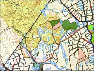
I created this map last night using the 1950's Topo Map from Historic USGS Maps of New England & NY from the Univeristy of New Hampshire and the Town of Newtown Open Space Taskforce Map to see if I could find a connection between my Burr Farm OS trail and the trail that runs north of Pond Brook after the Brook crosses under the road. Newtown Forest Association (NFA) Lands are in dark green and Town Open Space is Pink. Over the townline, you will notice a black lines that represent the Burr Farm OS Ride that I initally mapped. You may also notice that there is some sort of road that is shown that would appear to come from the NFA land towards the center of the map and looks like a stretched out S laying on its back. It would appear that there could be connection from the Burr Farm OS loop to this logging road, into the NFA lands, and then down to Pond Brook trail and spills out to the road. Hence the purpose of this morning's ride.

Find that loop!